
Thank you for supporting this site ❤️
Make a donation
Make a donation
Highland topographic map
Click on the map to display elevation.
Thank you for supporting this site ❤️
Make a donation
Make a donation
About this map
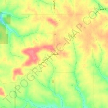
Name: Highland topographic map, elevation, terrain.
Location: Highland, Fillmore County, Minnesota, United States (43.66080 -91.89015 43.70080 -91.85015)
Average elevation: 351 m
Minimum elevation: 303 m
Maximum elevation: 387 m
Thank you for supporting this site ❤️
Make a donation
Make a donation
Other topographic maps
Click on a map to view its topography, its elevation and its terrain.
Thank you for supporting this site ❤️
Make a donation
Make a donation
Thank you for supporting this site ❤️
Make a donation
Make a donation
Fountain
United States > Minnesota > Fillmore County
Fountain is claimed as the sinkhole capital of the United States of America due to the prevalence of karst topography.
Average elevation: 387 m
Thank you for supporting this site ❤️
Make a donation
Make a donation