
Thank you for supporting this site ❤️
Make a donation
Make a donation
Posey County topographic map
Click on the map to display elevation.
Thank you for supporting this site ❤️
Make a donation
Make a donation
About this map
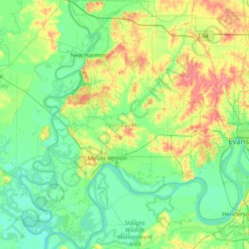
Name: Posey County topographic map, elevation, terrain.
Location: Posey County, Indiana, United States (37.77174 -88.09970 38.23040 -87.68837)
Average elevation: 122 m
Minimum elevation: 102 m
Maximum elevation: 179 m
Thank you for supporting this site ❤️
Make a donation
Make a donation
Other topographic maps
Click on a map to view its topography, its elevation and its terrain.