
Thank you for supporting this site ❤️
Make a donation
Make a donation
Lizella topographic map
Click on the map to display elevation.
Thank you for supporting this site ❤️
Make a donation
Make a donation
About this map
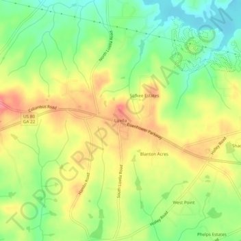
Name: Lizella topographic map, elevation, terrain.
Location: Lizella, Macon, Bibb County, Georgia, 31052, United States (32.78708 -83.83991 32.82708 -83.79991)
Average elevation: 146 m
Minimum elevation: 107 m
Maximum elevation: 185 m
Thank you for supporting this site ❤️
Make a donation
Make a donation
Other topographic maps
Click on a map to view its topography, its elevation and its terrain.
Ocmulgee Mounds National Historical Park
United States > Georgia > Bibb County > Macon
Average elevation: 96 m