
Make a donation
West Bend topographic map
Click on the map to display elevation.
Make a donation
West Bend
West Bend is in the Kettle Moraine region, and its topography is varied. The glacial activity has formed many kettles and hills throughout the region.
Make a donation
About this map
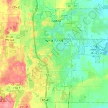
Name: West Bend topographic map, elevation, terrain.
Location: West Bend, Washington County, Wisconsin, United States (43.37029 -88.24651 43.45555 -88.11013)
Average elevation: 298 m
Minimum elevation: 260 m
Maximum elevation: 366 m
Make a donation
Other topographic maps
Click on a map to view its topography, its elevation and its terrain.
Milwaukee River Floodplain Forest State Natural Area
United States > Wisconsin > Washington County
Average elevation: 291 m
Allenton
United States > Wisconsin > Washington County
Allenton is located at latitude 43.421 and longitude -88.341. The elevation is 958 feet. Allenton has an area of 1.446 square miles (3.75 km2), all of it land. The Rock River cuts through the town.
Average elevation: 313 m