
Thank you for supporting this site ❤️
Make a donation
Make a donation
El Carmen topographic map
Click on the map to display elevation.
Thank you for supporting this site ❤️
Make a donation
Make a donation
About this map
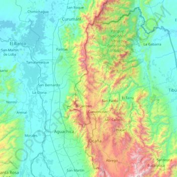
Name: El Carmen topographic map, elevation, terrain.
Location: El Carmen, Occidente, Norte de Santander, Colombia (7.94731 -74.10820 9.34731 -72.70820)
Average elevation: 528 m
Minimum elevation: 18 m
Maximum elevation: 3,015 m
Thank you for supporting this site ❤️
Make a donation
Make a donation