
Thank you for supporting this site ❤️
Make a donation
Make a donation
Le Havre topographic map
Click on the map to display elevation.
Thank you for supporting this site ❤️
Make a donation
Make a donation
About this map
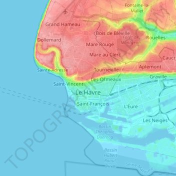
Name: Le Havre topographic map, elevation, terrain.
Location: Le Havre, Seine-Maritime, Normandy, Metropolitan France, France (49.45167 0.06680 49.54015 0.19556)
Average elevation: 27 m
Minimum elevation: -5 m
Maximum elevation: 102 m
Thank you for supporting this site ❤️
Make a donation
Make a donation
Other topographic maps
Click on a map to view its topography, its elevation and its terrain.
Le Tilleul - Antifer
France > Normandy > Seine-Maritime > La Poterie-Cap-d'Antifer
Average elevation: 42 m