
Thank you for supporting this site ❤️
Make a donation
Make a donation
Liège topographic map
Click on the map to display elevation.
Thank you for supporting this site ❤️
Make a donation
Make a donation
About this map
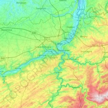
Name: Liège topographic map, elevation, terrain.
Location: Liège, Wallonie, Belgique (50.39548 5.34939 50.81212 5.81871)
Average elevation: 190 m
Minimum elevation: 48 m
Maximum elevation: 564 m
Thank you for supporting this site ❤️
Make a donation
Make a donation
Other topographic maps
Click on a map to view its topography, its elevation and its terrain.