
Thank you for supporting this site ❤️
Make a donation
Make a donation
Villa Guardia topographic map
Click on the map to display elevation.
Thank you for supporting this site ❤️
Make a donation
Make a donation
About this map
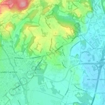
Name: Villa Guardia topographic map, elevation, terrain.
Location: Villa Guardia, Como, Lombardy, 22079, Italy (45.75743 8.99733 45.79018 9.04991)
Average elevation: 339 m
Minimum elevation: 300 m
Maximum elevation: 442 m
Thank you for supporting this site ❤️
Make a donation
Make a donation
Other topographic maps
Click on a map to view its topography, its elevation and its terrain.
Monte Bregagno
Italy > Lombardy > Como > Cremia
Monte Bregagno is a mountain of Lombardy, Italy, It has an elevation of 2,107 metres.
Average elevation: 1,688 m
Thank you for supporting this site ❤️
Make a donation
Make a donation
Thank you for supporting this site ❤️
Make a donation
Make a donation
Thank you for supporting this site ❤️
Make a donation
Make a donation
Thank you for supporting this site ❤️
Make a donation
Make a donation