
Bubbenhall topographic map
Click on the map to display elevation.
About this map
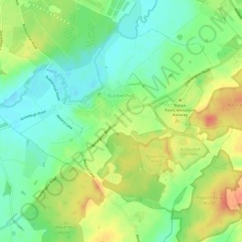
Name: Bubbenhall topographic map, elevation, terrain.
Location: Bubbenhall, Warwick, Warwickshire, England, United Kingdom (52.33410 -1.49686 52.35891 -1.44363)
Average elevation: 78 m
Minimum elevation: 57 m
Maximum elevation: 105 m
Other topographic maps
Click on a map to view its topography, its elevation and its terrain.
Rowington Green
United Kingdom > England > Warwickshire > Warwick > Rowington
Average elevation: 114 m
Hampton on the Hill
United Kingdom > England > Warwickshire > Warwick > Hampton on the Hill
Average elevation: 75 m