
Thank you for supporting this site ❤️
Make a donation
Make a donation
Loma de Calamorro topographic map
Click on the map to display elevation.
Thank you for supporting this site ❤️
Make a donation
Make a donation
About this map
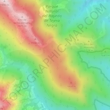
Name: Loma de Calamorro topographic map, elevation, terrain.
Average elevation: 1,672 m
Minimum elevation: 1,439 m
Maximum elevation: 1,982 m
Thank you for supporting this site ❤️
Make a donation
Make a donation
Other topographic maps
Click on a map to view its topography, its elevation and its terrain.
Parque Natural del Hayedo de Tejera Negra
España > Castilla-La Mancha > Cantalojas
Average elevation: 1,626 m