
Lüsens topographic map
Interactive map
Click on the map to display elevation.
About this map
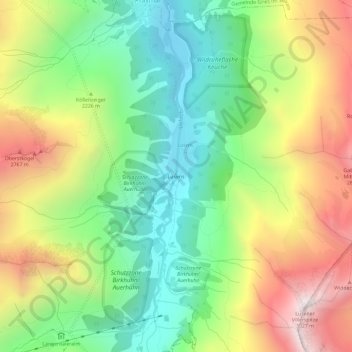
Name: Lüsens topographic map, elevation, terrain.
Average elevation: 2,169 m
Minimum elevation: 1,594 m
Maximum elevation: 2,999 m
Other topographic maps
Click on a map to view its topography, its elevation and its terrain.
Pforzheimer Hütte
Österreich > Tirol > Bezirk Innsbruck-Land > Gemeinde Sankt Sigmund im Sellrain
Pforzheimer Hütte, 19a, Via Mandani, Gemeinde Sankt Sigmund im Sellrain, Bezirk Innsbruck-Land, Tirol, 6184, Österreich
Average elevation: 2,474 m