
Thank you for supporting this site ❤️
Make a donation
Make a donation
La Fundición topographic map
Click on the map to display elevation.
Thank you for supporting this site ❤️
Make a donation
Make a donation
About this map
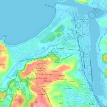
Name: La Fundición topographic map, elevation, terrain.
Location: La Fundición, Castrillón, Asturias, 33405, España (43.55433 -5.96213 43.59433 -5.92213)
Average elevation: 20 m
Minimum elevation: -6 m
Maximum elevation: 98 m
Thank you for supporting this site ❤️
Make a donation
Make a donation
Other topographic maps
Click on a map to view its topography, its elevation and its terrain.