
Thank you for supporting this site ❤️
Make a donation
Make a donation
Paillaco topographic map
Click on the map to display elevation.
Thank you for supporting this site ❤️
Make a donation
Make a donation
About this map
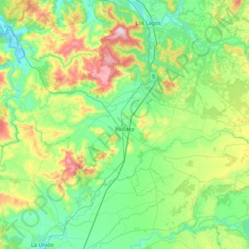
Name: Paillaco topographic map, elevation, terrain.
Average elevation: 176 m
Minimum elevation: -2 m
Maximum elevation: 746 m
Thank you for supporting this site ❤️
Make a donation
Make a donation
Other topographic maps
Click on a map to view its topography, its elevation and its terrain.
Panguipulli
Chile > Los Ríos Region > Provincia de Valdivia > Panguipulli > Panguipulli
Average elevation: 226 m