
Thank you for supporting this site ❤️
Make a donation
Make a donation
Wanea topographic map
Click on the map to display elevation.
Thank you for supporting this site ❤️
Make a donation
Make a donation
About this map
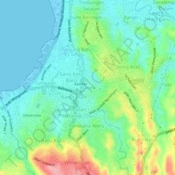
Name: Wanea topographic map, elevation, terrain.
Location: Wanea, Manado, North Sulawesi, Sulawesi, 95117, Indonesia (1.44347 124.82068 1.48347 124.86068)
Average elevation: 36 m
Minimum elevation: -1 m
Maximum elevation: 128 m
Thank you for supporting this site ❤️
Make a donation
Make a donation
Other topographic maps
Click on a map to view its topography, its elevation and its terrain.