
Thank you for supporting this site ❤️
Make a donation
Make a donation
Leadburn topographic map
Click on the map to display elevation.
Thank you for supporting this site ❤️
Make a donation
Make a donation
About this map
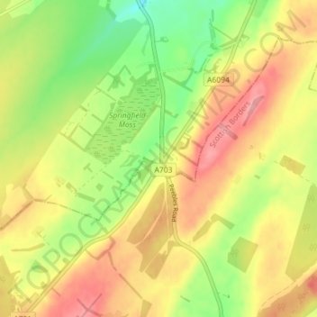
Name: Leadburn topographic map, elevation, terrain.
Location: Leadburn, Midlothian, Scotland, EH46 7BE, United Kingdom (55.76690 -3.24242 55.80690 -3.20242)
Average elevation: 271 m
Minimum elevation: 218 m
Maximum elevation: 319 m
Thank you for supporting this site ❤️
Make a donation
Make a donation
Other topographic maps
Click on a map to view its topography, its elevation and its terrain.
Straiton Pond Local Nature Reserve
United Kingdom > Scotland > Midlothian > Loanhead
Average elevation: 131 m