
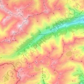
Bedretto topographic map
Interactive map
Click on the map to display elevation.
About this map
Name: Bedretto topographic map, elevation, terrain.
Average elevation: 2,250 m
Minimum elevation: 1,143 m
Maximum elevation: 3,138 m
La commune de Bedretto dispose, dans le hameau de Cioss Prato, d'un petit domaine skiable composé d'un téléski et d'un baby-lift. Le téléski, d'une longueur de 250 m, est implanté entre 1 550 m et 1 610 m d'altitude.
Other topographic maps
Click on a map to view its topography, its elevation and its terrain.
Corno Gries / Grieshorn
Suisse > Tessin > District de Léventine > Bedretto
Corno Gries / Grieshorn, Bedretto, Circolo di Airolo, District de Léventine, Tessin, 6781, Suisse
Average elevation: 2,557 m
Faido
Suisse > Tessin > District de Léventine
Faido, Circolo di Faido, District de Léventine, Tessin, Suisse
Average elevation: 1,713 m
Rossura
Suisse > Tessin > District de Léventine > Chiggiogna
Rossura, Chiggiogna, Faido, Circolo di Faido, District de Léventine, Tessin, 6760, Suisse
Average elevation: 1,279 m
Piotta
Suisse > Tessin > District de Léventine
Piotta, Quinto, Circolo di Quinto, District de Léventine, Tessin, 6776, Suisse
Average elevation: 1,517 m
Cascata Piumogna
Suisse > Tessin > District de Léventine > Mairengo
Cascata Piumogna, Mairengo, Faido, Circolo di Faido, District de Léventine, Tessin, 6763, Suisse
Average elevation: 1,023 m
Giornico
Suisse > Tessin > District de Léventine
Giornico, Cercle de Giornico, District de Léventine, Tessin, 6745, Suisse
Average elevation: 1,205 m
Capanna Corno Gries CAS
Suisse > Tessin > District de Léventine > Bedretto
Capanna Corno Gries CAS, gta, Corno, Bedretto, Circolo di Airolo, District de Léventine, Tessin, 6781, Suisse
Average elevation: 2,417 m
All'Acqua
Suisse > Tessin > District de Léventine > Bedretto
All'Acqua, Bedretto, Circolo di Airolo, District de Léventine, Tessin, 6781, Suisse
Average elevation: 2,033 m