
Thank you for supporting this site ❤️
Make a donation
Make a donation
Franklin County topographic map
Click on the map to display elevation.
Thank you for supporting this site ❤️
Make a donation
Make a donation
About this map
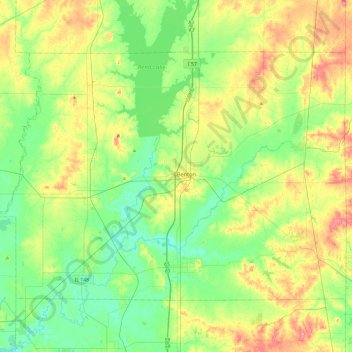
Name: Franklin County topographic map, elevation, terrain.
Location: Franklin County, Illinois, United States (37.86223 -89.17939 38.12724 -88.70371)
Average elevation: 134 m
Minimum elevation: 106 m
Maximum elevation: 182 m
Thank you for supporting this site ❤️
Make a donation
Make a donation
Other topographic maps
Click on a map to view its topography, its elevation and its terrain.
Thank you for supporting this site ❤️
Make a donation
Make a donation
Lake Zurich Highlands
United States > Illinois > Lake Zurich > Lake Zurich Highlands
Average elevation: 261 m
Thank you for supporting this site ❤️
Make a donation
Make a donation
Thank you for supporting this site ❤️
Make a donation
Make a donation