
Thank you for supporting this site ❤️
Make a donation
Make a donation
Ramot Naftali topographic map
Click on the map to display elevation.
Thank you for supporting this site ❤️
Make a donation
Make a donation
About this map
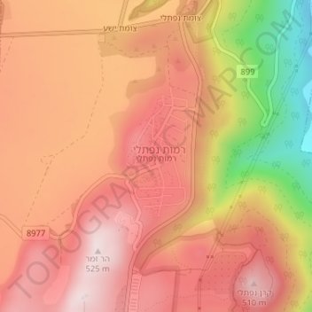
Name: Ramot Naftali topographic map, elevation, terrain.
Average elevation: 372 m
Minimum elevation: 84 m
Maximum elevation: 524 m
Thank you for supporting this site ❤️
Make a donation
Make a donation
Other topographic maps
Click on a map to view its topography, its elevation and its terrain.
Korazim National Park
Israel > North District > Mevoot HaHermon Regional Council
Average elevation: 97 m
Ein Avazim Nature Reserve
Israel > North District > Mevoot HaHermon Regional Council
Average elevation: 186 m