
Thank you for supporting this site ❤️
Make a donation
Make a donation
Orange topographic map
Click on the map to display elevation.
Thank you for supporting this site ❤️
Make a donation
Make a donation
About this map
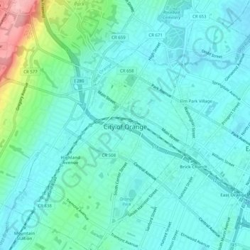
Name: Orange topographic map, elevation, terrain.
Location: Orange, Essex County, New Jersey, United States (40.75193 -74.25527 40.78980 -74.21843)
Average elevation: 70 m
Minimum elevation: 40 m
Maximum elevation: 202 m
Thank you for supporting this site ❤️
Make a donation
Make a donation
Other topographic maps
Click on a map to view its topography, its elevation and its terrain.