
Thank you for supporting this site ❤️
Make a donation
Make a donation
Lütt Moor topographic map
Click on the map to display elevation.
Thank you for supporting this site ❤️
Make a donation
Make a donation
About this map
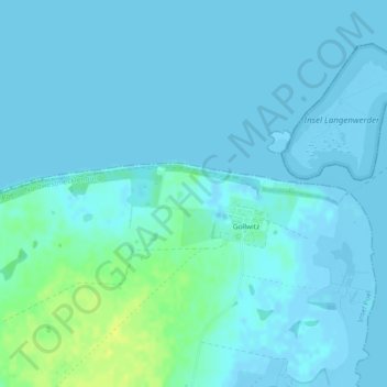
Name: Lütt Moor topographic map, elevation, terrain.
Average elevation: 3 m
Minimum elevation: -4 m
Maximum elevation: 17 m
Thank you for supporting this site ❤️
Make a donation
Make a donation
Other topographic maps
Click on a map to view its topography, its elevation and its terrain.
Langenwerder
Deutschland > Mecklenburg-Vorpommern > Nordwestmecklenburg > Gollwitz
Average elevation: 1 m