
Bergheim topographic map
Interactive map
Click on the map to display elevation.
About this map
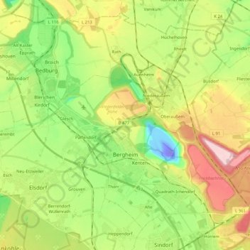
Name: Bergheim topographic map, elevation, terrain.
Location: Bergheim, Rhein-Erft-Kreis, Noordrijn-Westfalen, Duitsland (50.91598 6.56355 51.02190 6.76705)
Average elevation: 84 m
Minimum elevation: -85 m
Maximum elevation: 206 m
Other topographic maps
Click on a map to view its topography, its elevation and its terrain.
Sindorf
Duitsland > Noordrijn-Westfalen > Rhein-Erft-Kreis
Sindorf, Kerpen, Rhein-Erft-Kreis, Noordrijn-Westfalen, 50170, Duitsland
Average elevation: 85 m
Paffendorf
Duitsland > Noordrijn-Westfalen > Rhein-Erft-Kreis > Bergheim
Paffendorf, Bergheim, Rhein-Erft-Kreis, Noordrijn-Westfalen, 50126, Duitsland
Average elevation: 72 m
Erftstadt
Duitsland > Noordrijn-Westfalen > Rhein-Erft-Kreis
Erftstadt, Rhein-Erft-Kreis, Noordrijn-Westfalen, 50374, Duitsland
Average elevation: 119 m