
Hyderabad topographic map
Interactive map
Click on the map to display elevation.
About this map
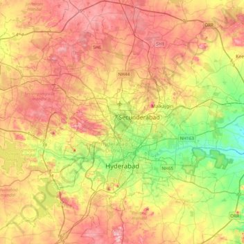
Name: Hyderabad topographic map, elevation, terrain.
Average elevation: 549 m
Minimum elevation: 447 m
Maximum elevation: 649 m
Hyderabad est bâtie au nord du Deccan sur les rives de la rivière Musi, à une altitude de 542 m. Elle possède de nombreux sagar (lacs) comme l'Osman Sagar, l'Hussein Sagar ou l'Himayat Sagar pour citer les plus grands des 140 lacs de la ville.
Other topographic maps
Click on a map to view its topography, its elevation and its terrain.
Hyderabad
Inde > Telangana > Bahadurpura mandal > Hyderabad
Hyderabad, Bahadurpura mandal, Hyderabad, Telangana, 500 002, Inde
Average elevation: 545 m