
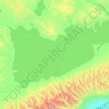
གནམ་མཚོ་ (纳木错) topographic map
Interactive map
Click on the map to display elevation.
About this map
Name: གནམ་མཚོ་ (纳木错) topographic map, elevation, terrain.
Average elevation: 4,920 m
Minimum elevation: 4,190 m
Maximum elevation: 7,129 m
Other topographic maps
Click on a map to view its topography, its elevation and its terrain.
昂仁县
China > Tibet > ངམ་རིང་རྫོང་ 昂仁县 > 卡嘎镇
昂仁县, 卡嘎镇, ངམ་རིང་རྫོང་ 昂仁县, Shigatse, Tibet, China
Average elevation: 4,636 m
Brahmaputra
China > Tibet > ལྷོ་ཁ་ས་ཁུལ། / 山南市 / Shannan
Brahmaputra, སྣ་དཀར་རྩེ་རྫོང་ / 浪卡子县 / Nagarzê, ལྷོ་ཁ་ས་ཁུལ། / 山南市 / Shannan, Tibet, China
Average elevation: 2,298 m