
Thank you for supporting this site ❤️
Make a donation
Make a donation
Khawa topographic map
Click on the map to display elevation.
Thank you for supporting this site ❤️
Make a donation
Make a donation
About this map
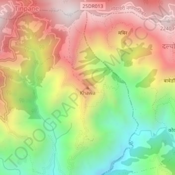
Name: Khawa topographic map, elevation, terrain.
Location: Khawa, Bagmati, Lalitpur, Bagamati Province, Nepal (27.52718 85.30826 27.52728 85.30836)
Average elevation: 1,739 m
Minimum elevation: 1,220 m
Maximum elevation: 2,246 m
Thank you for supporting this site ❤️
Make a donation
Make a donation
Other topographic maps
Click on a map to view its topography, its elevation and its terrain.
Kathmandu Valley
Nepal > Bagamati Province > Lalitpur
Kathmandu Valley is bowl-shaped. Its central lower part stands at 1,425 metres (4,675 ft). Kathmandu Valley is surrounded by five mountain ranges: Shivapuri hills (at an elevation of 2,732 metres (8,963 ft)), Phulchowki (2,762 metres or 9,062 feet), Nagarjun (2,128 metres or 6,982 feet), Champadevi (2,278…
Average elevation: 1,595 m
Thank you for supporting this site ❤️
Make a donation
Make a donation