
Thank you for supporting this site ❤️
Make a donation
Make a donation
Mainvault topographic map
Click on the map to display elevation.
Thank you for supporting this site ❤️
Make a donation
Make a donation
About this map
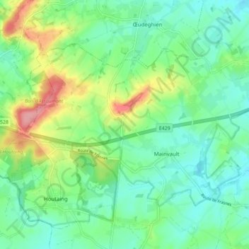
Name: Mainvault topographic map, elevation, terrain.
Location: Mainvault, Ath, Hainaut, Wallonie, 7812, Belgique (50.63802 3.66947 50.67393 3.75571)
Average elevation: 60 m
Minimum elevation: 32 m
Maximum elevation: 134 m
Thank you for supporting this site ❤️
Make a donation
Make a donation
Other topographic maps
Click on a map to view its topography, its elevation and its terrain.