
Thank you for supporting this site ❤️
Make a donation
Make a donation
Galeton topographic map
Click on the map to display elevation.
Thank you for supporting this site ❤️
Make a donation
Make a donation
About this map
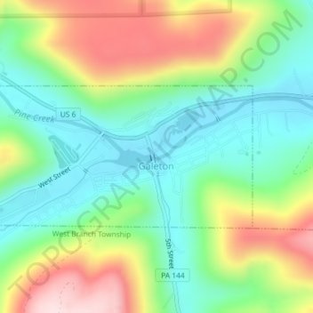
Name: Galeton topographic map, elevation, terrain.
Location: Galeton, Potter County, Pennsylvania, United States (41.72759 -77.66062 41.73991 -77.63055)
Average elevation: 515 m
Minimum elevation: 391 m
Maximum elevation: 727 m
Thank you for supporting this site ❤️
Make a donation
Make a donation
Other topographic maps
Click on a map to view its topography, its elevation and its terrain.
Cross Fork
United States > Pennsylvania > Potter County > Stewardson Township
Average elevation: 467 m
Thank you for supporting this site ❤️
Make a donation
Make a donation
Cross Fork
United States > Pennsylvania > Potter County > Stewardson Township
Average elevation: 467 m
Patterson State Park
United States > Pennsylvania > Potter County > Summit Township
Average elevation: 708 m
Kinney
United States > Pennsylvania > Potter County > Genesee Township > Kinney
Average elevation: 660 m
Thank you for supporting this site ❤️
Make a donation
Make a donation