
Thank you for supporting this site ❤️
Make a donation
Make a donation
Quaker City topographic map
Click on the map to display elevation.
Thank you for supporting this site ❤️
Make a donation
Make a donation
About this map
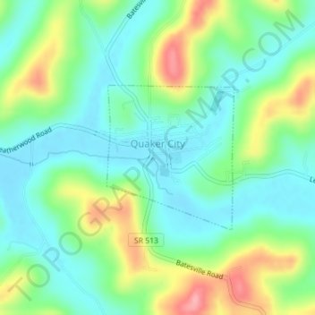
Name: Quaker City topographic map, elevation, terrain.
Location: Quaker City, Guernsey County, Ohio, United States (39.96257 -81.30499 39.97500 -81.29070)
Average elevation: 297 m
Minimum elevation: 260 m
Maximum elevation: 373 m
Thank you for supporting this site ❤️
Make a donation
Make a donation
Other topographic maps
Click on a map to view its topography, its elevation and its terrain.