
Thank you for supporting this site ❤️
Make a donation
Make a donation
Harbor Hills topographic map
Click on the map to display elevation.
Thank you for supporting this site ❤️
Make a donation
Make a donation
About this map
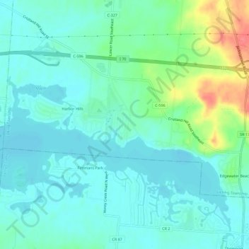
Name: Harbor Hills topographic map, elevation, terrain.
Location: Harbor Hills, Avondale, Licking County, Ohio, United States (39.92197 -82.46359 39.94698 -82.40778)
Average elevation: 283 m
Minimum elevation: 266 m
Maximum elevation: 336 m
Thank you for supporting this site ❤️
Make a donation
Make a donation
Other topographic maps
Click on a map to view its topography, its elevation and its terrain.