
Make a donation
South Bethlehem topographic map
Click on the map to display elevation.
Make a donation
About this map
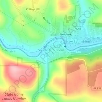
Name: South Bethlehem topographic map, elevation, terrain.
Average elevation: 388 m
Minimum elevation: 317 m
Maximum elevation: 486 m
Make a donation
Other topographic maps
Click on a map to view its topography, its elevation and its terrain.
Lake Keystone
United States > Pennsylvania > Armstrong County > Plumcreek Township
Keystone Lake (also known as Keystone Reservoir and Plum Creek Reservoir) is a reservoir in Armstrong County in the U.S. state of Pennsylvania. The elevation of Keystone Lake is 1,076 feet (328 m) above sea level.
Average elevation: 357 m
Crooked Creek Lake
United States > Pennsylvania > Armstrong County > Bethel Township
Average elevation: 288 m
Make a donation
Slate Lick
United States > Pennsylvania > Armstrong County > South Buffalo Township
Average elevation: 356 m
Williamsburg
United States > Pennsylvania > Armstrong County > East Franklin Township
Average elevation: 319 m