
Erandio topographic map
Interactive map
Click on the map to display elevation.
About this map
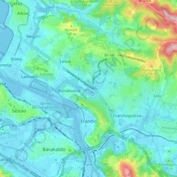
Name: Erandio topographic map, elevation, terrain.
Location: Erandio, Andraka, Vizcaya, País Vasco, 48620, España (43.28548 -2.99244 43.34912 -2.92410)
Average elevation: 42 m
Minimum elevation: -3 m
Maximum elevation: 229 m
Other topographic maps
Click on a map to view its topography, its elevation and its terrain.
Santsoena
España > País Vasco > Andraka > Lejona
Santsoena, Lejona, Andraka, Vizcaya, País Vasco, 48620, España
Average elevation: 38 m
Sestao
España > País Vasco > Andraka
Sestao, Andraka, Vizcaya, País Vasco, 48620, España
Average elevation: 22 m