
Thank you for supporting this site ❤️
Make a donation
Make a donation
Maule Region topographic map
Click on the map to display elevation.
Thank you for supporting this site ❤️
Make a donation
Make a donation
About this map
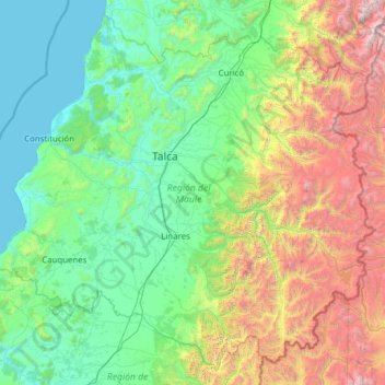
Name: Maule Region topographic map, elevation, terrain.
Location: Maule Region, Chile (-36.54362 -72.78638 -34.68453 -70.30761)
Average elevation: 908 m
Minimum elevation: 0 m
Maximum elevation: 4,855 m
Thank you for supporting this site ❤️
Make a donation
Make a donation
Other topographic maps
Click on a map to view its topography, its elevation and its terrain.
Thank you for supporting this site ❤️
Make a donation
Make a donation
Punta Santa Ana
Chile > Region of Magallanes and Chilean Antarctica > Provincia de Magallanes > Punta Arenas
Average elevation: 5 m
Villa Cerro Castillo
Chile > Aysén Region > Provincia de General Carrera > Río Ibáñez
Average elevation: 379 m