
San Ramon topographic map
Click on the map to display elevation.
San Ramon
The topography of San Ramon is varied, featuring a mix of the rolling hills of the Diablo Range and the flatter basin of the San Ramon Valley. The city is predominantly urban and residential with many new housing developments; however, much of the land around the city's perimeter regions remains undeveloped, and is covered by grasslands and oak tree orchards. During the drier months the grasses are golden, but with the precipitation of winter and spring, the grasses turn green.
About this map
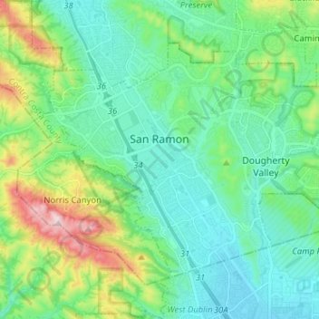
Name: San Ramon topographic map, elevation, terrain.
Location: San Ramon, Contra Costa County, California, United States (37.72124 -122.00448 37.79512 -121.87693)
Average elevation: 210 m
Minimum elevation: 101 m
Maximum elevation: 560 m
Other topographic maps
Click on a map to view its topography, its elevation and its terrain.
Contra Costa Centre
United States > California > Contra Costa County
Contra Costa Centre is an unincorporated community and census-designated place in Contra Costa County, California. Contra Costa Centre sits at an elevation of 92 feet (28 m). The 2010 United States census reported Contra Costa Centre's population was 5,364, while the 2020 census figure was 6,808. Contra Costa…
Average elevation: 36 m
Lafayette Reservoir
United States > California > Contra Costa County > Lafayette
Average elevation: 174 m
Saranap
United States > California > Contra Costa County
Saranap (until 1913, Dewing Park) is a residential census-designated place (CDP) within central Contra Costa County, California. Lying at an elevation of 180 feet (55 m), it is bounded on the south and east by portions of Walnut Creek (including the gated senior residential development Rossmoor) and on the…
Average elevation: 92 m
North Richmond
United States > California > Contra Costa County > North Richmond
Average elevation: 6 m
Crolona Heights
United States > California > Contra Costa County > Crockett > Crolona Heights
Average elevation: 61 m