Town of Southampton topographic map
Interactive map
Click on the map to display elevation.
About this map
![Town of Southampton topographic map, elevation, terrain](/pub/maps/relation/3zgt/v9pszs/thumbnail.jpg)
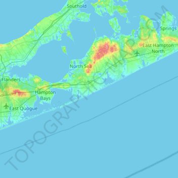
Name: Town of Southampton topographic map, elevation, terrain.
Location: Town of Southampton, Suffolk County, New York, United States (40.71772 -72.72943 41.04502 -72.21060)
Average elevation: 4 m
Minimum elevation: -5 m
Maximum elevation: 83 m
Other topographic maps
Click on a map to view its topography, its elevation and its terrain.
![Montauk topographic map, elevation, terrain](/pub/maps/relation/s2tp/tnzcz/icon.jpg)
Montauk
United States > New York > Suffolk County > Town of East Hampton
Montauk, Town of East Hampton, Suffolk County, New York, 11954, United States
Average elevation: 2 m
![Westhampton topographic map, elevation, terrain](/pub/maps/relation/7hf3/x9lkl/icon.jpg)
Westhampton
United States > New York > Suffolk County > Town of Southampton
Westhampton, Town of Southampton, Suffolk County, New York, 11977, United States
Average elevation: 11 m
![Blue Point topographic map, elevation, terrain](/pub/maps/relation/535k/4pzm2/icon.jpg)
Blue Point
United States > New York > Suffolk County > Town of Brookhaven
Blue Point, Town of Brookhaven, Suffolk County, New York, 11715, United States
Average elevation: 7 m
![Mastic Beach topographic map, elevation, terrain](/pub/maps/relation/3rgt/dlhz4/icon.jpg)
Mastic Beach
United States > New York > Suffolk County > Town of Brookhaven
Mastic Beach, Town of Brookhaven, Suffolk County, New York, 11951, United States
Average elevation: 3 m
![Town of Shelter Island topographic map, elevation, terrain](/pub/maps/relation/9j9m/19x1f3/icon.jpg)
Town of Shelter Island
United States > New York > Suffolk County
Town of Shelter Island, Suffolk County, New York, United States
Average elevation: 3 m
![Dix Hills topographic map, elevation, terrain](/pub/maps/relation/qfnx/978zs/icon.jpg)
Dix Hills
United States > New York > Suffolk County > Town of Huntington
Dix Hills, Town of Huntington, Suffolk County, New York, United States
Average elevation: 53 m
![Selden topographic map, elevation, terrain](/pub/maps/relation/h5m2/6fh9m/icon.jpg)
Selden
United States > New York > Suffolk County > Town of Brookhaven
Selden, Town of Brookhaven, Suffolk County, New York, 11784, United States
Average elevation: 41 m
![Village of Nissequogue topographic map, elevation, terrain](/pub/maps/relation/7zb3/n173q/icon.jpg)
Village of Nissequogue
United States > New York > Suffolk County > Town of Smithtown
Village of Nissequogue, Town of Smithtown, Suffolk County, New York, United States
Average elevation: 19 m
![Calverton topographic map, elevation, terrain](/pub/maps/relation/gmt6/w93tf/icon.jpg)
Calverton
United States > New York > Suffolk County
Calverton, Town of Riverhead, Suffolk County, New York, 11933, United States
Average elevation: 26 m
![Village of Belle Terre topographic map, elevation, terrain](/pub/maps/relation/fbz4/7dr18/icon.jpg)
Village of Belle Terre
United States > New York > Suffolk County > Town of Brookhaven
Village of Belle Terre, Town of Brookhaven, Suffolk County, New York, United States
Average elevation: 20 m
![Stony Brook topographic map, elevation, terrain](/pub/maps/relation/x8tf/m4151/icon.jpg)
Stony Brook
United States > New York > Suffolk County
Stony Brook, Town of Brookhaven, Suffolk County, New York, United States
Average elevation: 29 m
![Setauket topographic map, elevation, terrain](/pub/maps/relation/3f9m/3zqpnx/icon.jpg)
Setauket
United States > New York > Suffolk County
Setauket, Town of Brookhaven, Suffolk County, New York, United States
Average elevation: 14 m
![East Setauket topographic map, elevation, terrain](/pub/maps/node/q5k/4g6tnm2/icon.jpg)
East Setauket
United States > New York > Suffolk County > East Setauket
East Setauket, Town of Brookhaven, Suffolk County, New York, 11733, United States
Average elevation: 43 m
![Montauk Beach topographic map, elevation, terrain](/pub/maps/node/lx18/b41pkt6/icon.jpg)
Montauk Beach
United States > New York > Suffolk County > Montauk
Montauk Beach, Montauk, Town of East Hampton, Suffolk County, New York, 11954, United States
Average elevation: 13 m
![Orient topographic map, elevation, terrain](/pub/maps/relation/f114/9784s/icon.jpg)
Orient
United States > New York > Suffolk County > Town of Southold
Orient, Town of Southold, Suffolk County, New York, United States
Average elevation: 2 m
![Town of Islip topographic map, elevation, terrain](/pub/maps/relation/4rnh/n9hxkl/icon.jpg)
Town of Islip
United States > New York > Suffolk County > Town of Islip
Town of Islip, Suffolk County, New York, United States
Average elevation: 12 m
![Riverhead topographic map, elevation, terrain](/pub/maps/relation/7nf3/xk8kl/icon.jpg)
Riverhead
United States > New York > Suffolk County > Riverhead
Riverhead, Town of Riverhead, Suffolk County, New York, United States
Average elevation: 13 m
![Babylon topographic map, elevation, terrain](/pub/maps/relation/g1t6/w9ntf/icon.jpg)
Babylon
United States > New York > Suffolk County > Babylon
Babylon, Suffolk County, New York, 11702, United States
Average elevation: 4 m
![Holbrook topographic map, elevation, terrain](/pub/maps/relation/7nb3/n1b3q/icon.jpg)
Holbrook
United States > New York > Suffolk County
Holbrook, Town of Islip, Suffolk County, New York, 11741, United States
Average elevation: 28 m