
Make a donation
Tarbrax topographic map
Click on the map to display elevation.
Make a donation
About this map
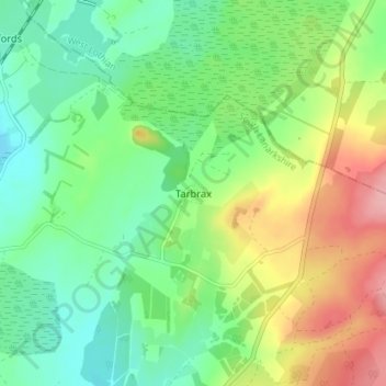
Name: Tarbrax topographic map, elevation, terrain.
Location: Tarbrax, South Lanarkshire, Scotland, EH55 8XE, United Kingdom (55.76053 -3.57322 55.80053 -3.53322)
Average elevation: 290 m
Minimum elevation: 248 m
Maximum elevation: 364 m
Make a donation
Other topographic maps
Click on a map to view its topography, its elevation and its terrain.
Langlands Moss Lowland Raised Peatbog
United Kingdom > Scotland > South Lanarkshire > East Kilbride
Average elevation: 204 m
Clyde Valley Family Park's Island
United Kingdom > Scotland > South Lanarkshire > Hazelbank > Birkhill
Average elevation: 119 m
Craignethan Castle
United Kingdom > Scotland > South Lanarkshire > Crossford > Tillietudlem
Average elevation: 121 m
Langlands Moss Local Nature Reserve
United Kingdom > Scotland > South Lanarkshire > East Kilbride
Average elevation: 204 m
Make a donation
Trough Linn Woodlands Project
United Kingdom > Scotland > South Lanarkshire > East Kilbride
Average elevation: 185 m
Make a donation
Low Banks
United Kingdom > Scotland > South Lanarkshire > Lamington > Millhill
Average elevation: 263 m