
Thank you for supporting this site ❤️
Make a donation
Make a donation
Tulwet topographic map
Click on the map to display elevation.
Thank you for supporting this site ❤️
Make a donation
Make a donation
About this map
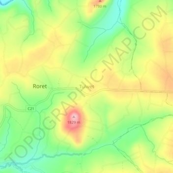
Name: Tulwet topographic map, elevation, terrain.
Location: Tulwet, Bureti, Kericho County, Rift Valley, Kenya (-0.50808 35.10876 -0.46808 35.14876)
Average elevation: 1,727 m
Minimum elevation: 1,641 m
Maximum elevation: 1,825 m
Thank you for supporting this site ❤️
Make a donation
Make a donation
Other topographic maps
Click on a map to view its topography, its elevation and its terrain.