

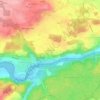
Ittigen topographic map
Click on the map to display elevation.
Ittigen
The municipality is located in the Worblental (Worblen valley) on a terrace on the Mannenberg (elevation 688 m [2,257 ft]) in the agglomeration of Bern.
About this map

Name: Ittigen topographic map, elevation, terrain.
Average elevation: 595 m
Minimum elevation: 493 m
Maximum elevation: 811 m
Other topographic maps
Click on a map to view its topography, its elevation and its terrain.
Oberdettigen
Switzerland > Bern > Bern-Mittelland administrative district > Hinterkappelen
Average elevation: 566 m