
Make a donation
Johnson County topographic map
Click on the map to display elevation.
Make a donation
Johnson County
The natural topography of the county consists of gently rolling terrain. The Kansas River forms a portion of the northwest boundary of the county. The elevation generally increases from north to south as the distance from the Kansas and Missouri rivers increases.
Make a donation
About this map
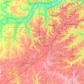
Name: Johnson County topographic map, elevation, terrain.
Location: Johnson County, Kansas, United States (38.73810 -95.05650 39.06166 -94.60738)
Average elevation: 297 m
Minimum elevation: 221 m
Maximum elevation: 347 m
Make a donation
Other topographic maps
Click on a map to view its topography, its elevation and its terrain.
Great Plains
United States > Kansas > Thomas County
The North American Environmental Atlas, produced by the Commission for Environmental Cooperation, a North American Free Trade Agreement (NAFTA) agency composed of the geographical agencies of the Mexican, American, and Canadian governments, uses the "Great Plains" as an ecoregion synonymous with predominant…
Average elevation: 1,023 m
Lawrence
United States > Kansas > Lawrence
Downtown Lawrence is located at 38°58′18″N 95°14′7″W / 38.97167°N 95.23528°W / 38.97167; -95.23528 (38.959902, −95.253199), approximately 25 miles (40 kilometers) east of Topeka, and 35 mi (56 km) west of Kansas City, Kansas. Though Lawrence has a designated elevation of 866 feet (264…
Average elevation: 283 m