
Thank you for supporting this site ❤️
Make a donation
Make a donation
Wonokerso topographic map
Click on the map to display elevation.
Thank you for supporting this site ❤️
Make a donation
Make a donation
About this map
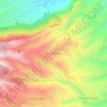
Name: Wonokerso topographic map, elevation, terrain.
Location: Wonokerso, Probolinggo, East Java, Java, Indonesia (-7.96740 113.00789 -7.92740 113.04789)
Average elevation: 1,858 m
Minimum elevation: 1,375 m
Maximum elevation: 2,315 m
Thank you for supporting this site ❤️
Make a donation
Make a donation
Other topographic maps
Click on a map to view its topography, its elevation and its terrain.
Suaka Margasatwa Dataran Tinggi Yang
Indonesia > East Java > Probolinggo > Situbondo
Average elevation: 1,885 m