
Thank you for supporting this site ❤️
Make a donation
Make a donation
Florence topographic map
Click on the map to display elevation.
Thank you for supporting this site ❤️
Make a donation
Make a donation
About this map
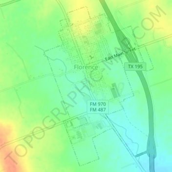
Name: Florence topographic map, elevation, terrain.
Location: Florence, Williamson County, Texas, 76572, United States (30.82571 -97.80139 30.85085 -97.78123)
Average elevation: 305 m
Minimum elevation: 288 m
Maximum elevation: 330 m
Thank you for supporting this site ❤️
Make a donation
Make a donation
Other topographic maps
Click on a map to view its topography, its elevation and its terrain.
Soil Conservation Service Site 12 Dam
United States > Texas > Williamson County > Type
Average elevation: 173 m