
Añelo topographic map
Interactive map
Click on the map to display elevation.
About this map
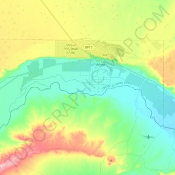
Name: Añelo topographic map, elevation, terrain.
Location: Añelo, Departamento Añelo, NQN, 8312, Argentina (-38.41275 -68.89714 -38.33386 -68.71361)
Average elevation: 461 m
Minimum elevation: 383 m
Maximum elevation: 610 m
Other topographic maps
Click on a map to view its topography, its elevation and its terrain.
Embalse de Pichi Picún Leufú
Embalse de Pichi Picún Leufú, Departamento Collón Curá, NQN, Argentina
Average elevation: 505 m
Nahuel Huapi National Park
Nahuel Huapi National Park, Sendero Cerro Centinela, Departamento Los Lagos, NQN, Argentina
Average elevation: 1,061 m