
Thank you for supporting this site ❤️
Make a donation
Make a donation
Weiherhöfen topographic map
Click on the map to display elevation.
Thank you for supporting this site ❤️
Make a donation
Make a donation
About this map
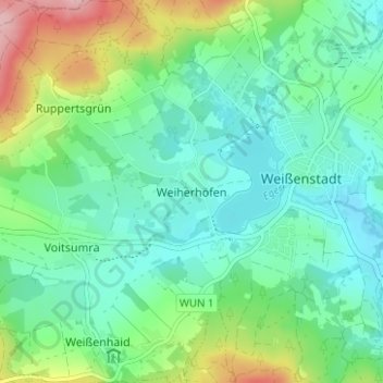
Name: Weiherhöfen topographic map, elevation, terrain.
Average elevation: 650 m
Minimum elevation: 605 m
Maximum elevation: 770 m
Thank you for supporting this site ❤️
Make a donation
Make a donation
Other topographic maps
Click on a map to view its topography, its elevation and its terrain.
Weißenstädter See
Deutschland > Bayern > Landkreis Wunsiedel im Fichtelgebirge > Weißenstadt > Weiherhöfen
Average elevation: 628 m