
Thank you for supporting this site ❤️
Make a donation
Make a donation
Cape Dorset topographic map
Click on the map to display elevation.
Thank you for supporting this site ❤️
Make a donation
Make a donation
About this map
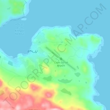
Name: Cape Dorset topographic map, elevation, terrain.
Location: Cape Dorset, Qikiqtaaluk Region, Nunavut, X0A 0C0, Canada (64.22316 -76.57066 64.23933 -76.49742)
Average elevation: 38 m
Minimum elevation: 0 m
Maximum elevation: 192 m
Thank you for supporting this site ❤️
Make a donation
Make a donation
Other topographic maps
Click on a map to view its topography, its elevation and its terrain.
Thank you for supporting this site ❤️
Make a donation
Make a donation
Thank you for supporting this site ❤️
Make a donation
Make a donation
Thor Peak
Canada > Nunavut > Qikiqtaaluk Region
Mount Thor, officially gazetted as Thor Peak (Inuktitut: ᙯᕐᓱᐊᓗᒃ Qaisualuk "huge bedrock" or Inuktitut: ᑭᒍᑎᙳᐊᖅ Kigutinnguaq "resembles a tooth"), is a mountain with an elevation of 1,675 metres (5,495 ft) located in Auyuittuq National Park, on Baffin Island, Nunavut, Canada. The mountain…
Average elevation: 690 m
Thank you for supporting this site ❤️
Make a donation
Make a donation