
Thank you for supporting this site ❤️
Make a donation
Make a donation
Bonnie Lake topographic map
Click on the map to display elevation.
Thank you for supporting this site ❤️
Make a donation
Make a donation
About this map
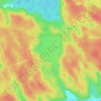
Name: Bonnie Lake topographic map, elevation, terrain.
Average elevation: 321 m
Minimum elevation: 286 m
Maximum elevation: 341 m
Thank you for supporting this site ❤️
Make a donation
Make a donation
Other topographic maps
Click on a map to view its topography, its elevation and its terrain.
South Branch Muskoka River;Spence Lake
Canada > Ontario > Muskoka District > Bracebridge
Average elevation: 275 m