
Thank you for supporting this site ❤️
Make a donation
Make a donation
Le Chatelard topographic map
Click on the map to display elevation.
Thank you for supporting this site ❤️
Make a donation
Make a donation
About this map
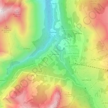
Name: Le Chatelard topographic map, elevation, terrain.
Average elevation: 1,575 m
Minimum elevation: 1,078 m
Maximum elevation: 2,135 m
Thank you for supporting this site ❤️
Make a donation
Make a donation
Other topographic maps
Click on a map to view its topography, its elevation and its terrain.
Lac Crintallia
France > Auvergne-Rhône-Alpes > Savoie > Saint-Martin-de-Belleville
Average elevation: 2,328 m
Glacier de Péclet
France > Auvergne-Rhône-Alpes > Savoie > Saint-Martin-de-Belleville
Average elevation: 2,996 m
Glacier de Thorens
France > Auvergne-Rhône-Alpes > Savoie > Saint-Martin-de-Belleville
Average elevation: 2,986 m
Lac du Lou
France > Auvergne-Rhône-Alpes > Savoie > Saint-Martin-de-Belleville
Average elevation: 2,290 m
Thank you for supporting this site ❤️
Make a donation
Make a donation