
Thank you for supporting this site ❤️
Make a donation
Make a donation
Monte Zerbion topographic map
Click on the map to display elevation.
Thank you for supporting this site ❤️
Make a donation
Make a donation
About this map
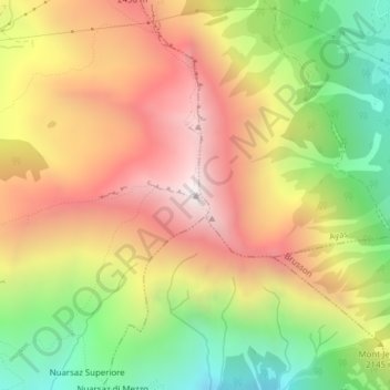
Name: Monte Zerbion topographic map, elevation, terrain.
Location: Monte Zerbion, Châtillon, Valle d'Aosta, 11027, Italia (45.78805 7.66354 45.78815 7.66364)
Average elevation: 2,096 m
Minimum elevation: 1,441 m
Maximum elevation: 2,704 m
Thank you for supporting this site ❤️
Make a donation
Make a donation
Other topographic maps
Click on a map to view its topography, its elevation and its terrain.