
Make a donation
Mount Ruapehu topographic map
Click on the map to display elevation.
Make a donation
Mount Ruapehu
Ruapehu has a polar tundra climate (Köppen: ET) on the upper slopes, with average temperatures ranging from −4–15 °C in summer and −7–7 °C in winter, depending on elevation and cloudiness. On the lower slopes, Ruapehu has a subpolar oceanic climate (Köppen: Cfc).
Make a donation
About this map
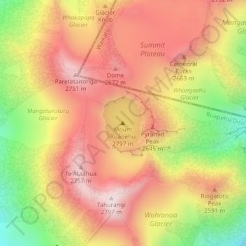
Name: Mount Ruapehu topographic map, elevation, terrain.
Average elevation: 2,474 m
Minimum elevation: 2,077 m
Maximum elevation: 2,755 m
Make a donation
Other topographic maps
Click on a map to view its topography, its elevation and its terrain.
Ohakune
New Zealand > Manawatu-Whanganui > Ruapehu District
Ohakune is located in the Ruapehu District and the Manawatū-Whanganui region, to the immediate south-west of the slopes of the Mount Ruapehu stratovolcano. The associated Ohakune volcanic complex is just to the north of the town and the small maar lakes Rangatauanui and Rangatauaiti are to the south of the…
Average elevation: 595 m
Waiouru
New Zealand > Manawatu-Whanganui > Ruapehu District
Waiouru's climate is mild, with very little temperature variation from month to month throughout the year, but because of its high altitude and close proximity to Mt Ruapehu it is still relatively cool compared to other North Island population centres, and can get quite cold at anytime of the year when the…
Average elevation: 814 m
Make a donation
Tongariro National Park
New Zealand > Manawatu-Whanganui > Ruapehu District
The first development in the young Tongariro National Park was the construction of tourist huts at the beginning of the 20th century, but it was not until the opening of the North Island Main Trunk railway line between Auckland and Wellington in 1908 and the building of roads in the 1920s that a significant…
Average elevation: 888 m
Make a donation
Te Onetapu / Rangipo Desert
New Zealand > Manawatu-Whanganui > Ruapehu District
Much of the desert lies at an altitude of over 600 m (2,000 ft), and a considerable proportion of it is over 1,000 m (3,300 ft) above sea level. Many of the North Island's largest rivers have their headwaters in the area, particularly around the slopes of Mount Ruapehu, the North Island's highest mountain.…
Average elevation: 1,015 m
Tongariro National Park
New Zealand > Manawatu-Whanganui > Ruapehu District
Like the whole of New Zealand, Tongariro National Park is situated in a temperate zone. The prevailing westerly winds gather water over the Tasman Sea. As the volcanoes of Tongariro National Park are the first significant elevations that these winds encounter on the North Island, besides Mount Taranaki, rain…
Average elevation: 888 m