
Make a donation
São Jorge topographic map
Click on the map to display elevation.
Make a donation
São Jorge
Fifty kilometres from the regional capital, the parish is located 240 metres above sea level, limited in the north by the Atlantic Ocean and south by the mountains of the interior range (the heightest altitudes in the parish include Pico Canário 1,592 metres (5,223 ft) and Pico dos Assumadouros 1,184 metres (3,885 ft). To the west is the civil parish of Arco de São Jorge and east are the parishes of Ilha and Santana. About half of the parish is covered by the rich Laurissilva forest defined as Natural Heritage by UNESCO.
Make a donation
About this map
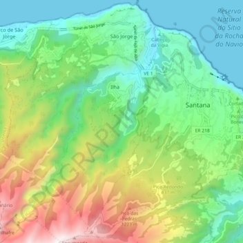
Name: São Jorge topographic map, elevation, terrain.
Location: São Jorge, Santana, Madeira, Portugal (32.76174 -16.96055 32.83761 -16.89639)
Average elevation: 581 m
Minimum elevation: -1 m
Maximum elevation: 1,767 m
Make a donation
Other topographic maps
Click on a map to view its topography, its elevation and its terrain.
Ruivo
As the highest point in the archipelago, Pico Ruivo is primarily surrounded by high-altitude heath. The area is also marked by monumental rock formations, which often rise above the clouds, dominating the landscape. The region is home to several bird species, including the Madeira firecrest, the chaffinch, and…
Average elevation: 1,400 m
Make a donation
Make a donation
Ruivo
As the highest point in the archipelago, Pico Ruivo is primarily surrounded by high-altitude heath. The area is also marked by monumental rock formations, which often rise above the clouds, dominating the landscape. The region is home to several bird species, including the Madeira firecrest, the chaffinch, and…
Average elevation: 1,400 m