
Thank you for supporting this site ❤️
Make a donation
Make a donation
Tacarigua topographic map
Click on the map to display elevation.
Thank you for supporting this site ❤️
Make a donation
Make a donation
About this map
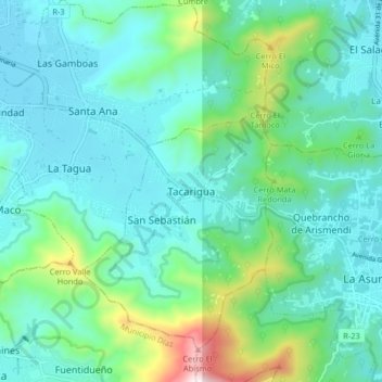
Name: Tacarigua topographic map, elevation, terrain.
Average elevation: 174 m
Minimum elevation: 9 m
Maximum elevation: 851 m
Thank you for supporting this site ❤️
Make a donation
Make a donation
Other topographic maps
Click on a map to view its topography, its elevation and its terrain.
Playa Bahía de Plata
Venezuela > Estado Nueva Esparta > Municipio Gómez > Altagracia
Average elevation: 13 m