
Thank you for supporting this site ❤️
Make a donation
Make a donation
Kejayaan topographic map
Click on the map to display elevation.
Thank you for supporting this site ❤️
Make a donation
Make a donation
About this map
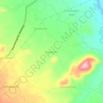
Name: Kejayaan topographic map, elevation, terrain.
Location: Kejayaan, Tanggamus, Lampung, Sumatra, Indonesia (-5.40513 104.76819 -5.36513 104.80819)
Average elevation: 270 m
Minimum elevation: 190 m
Maximum elevation: 385 m
Thank you for supporting this site ❤️
Make a donation
Make a donation
Other topographic maps
Click on a map to view its topography, its elevation and its terrain.