
Le Moulin d'Anglard topographic map
Interactive map
Click on the map to display elevation.
About this map
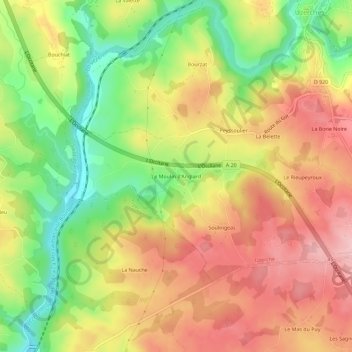
Name: Le Moulin d'Anglard topographic map, elevation, terrain.
Average elevation: 354 m
Minimum elevation: 257 m
Maximum elevation: 438 m
Other topographic maps
Click on a map to view its topography, its elevation and its terrain.
Le Bois de Phili
France > Nouvelle-Aquitaine > Corrèze > Uzerche
Le Bois de Phili, Uzerche, Tulle, Corrèze, Nouvelle-Aquitaine, France métropolitaine, 19140, France
Average elevation: 376 m
La Borie Noire
France > Nouvelle-Aquitaine > Corrèze > Uzerche > La Borie Noire
La Borie Noire, Uzerche, Tulle, Corrèze, Nouvelle-Aquitaine, France métropolitaine, 19140, France
Average elevation: 376 m